CANABAE NOVAE 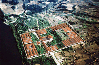  Field survey on the area of the canabae
and late Roman suburbium 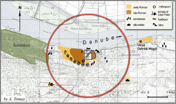
The legionary fortress in Novae, like similar military bases, was surrounded by a civilian settlement (canabae).
Both these areas constituted a specific settlement complex. The topography as well as the urbanistic structure of such settlements have so far been poorly recognised of this kind is not well-recognized, since only a few of them have been so far excavated. These were furthermore sites located in the western
part of the Empire. 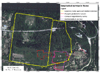
The civil settlement (Canabae) at Novae is one of the few sites in the lower danubian provinces witch can be archaeologically investigated.
However the site has not an easy access, becouse of the prsence of numerous
legal and illegal plots and a lush vegetation. Another problem is connected to the activity of looters, who irreversibly destory further structures. This is the reason why we decide to start our investigations in thi area as soon as possible.
The choise of a well considered research programme and adequate methods was highly expected in order to deal with the coplicated process of documenting the remains of the civil settlement around the camp in Novae.
The exclusive use of non-intrusive methods was adopted due to the large surface of the site as well as practical matters, since they would deliver an important amount of information in the shortest timespan.
Apart from the geophysical survey, being the most crucial task, the site was photographed, investigated with metal detectors, and
measured in details in order to obtain data in order to work out a 3D model of the site.
In the meantime, a query conducted in museums and archives had been performed, the aims of which were the preparation of a catalogue of finds that have been unearthed in the area of the civiian settlement and the cemeteries surrounding the camp as well aw the depiction of the local people's everyday life.
These data will be enriched by the palynological analyses which will helped us reconstructing the past environment.
The expected result is a virtual reconstruction of novae settlement landscape, as well as its topography, natural environment, landscape and urbanistic planning, as well as the understanding of this material culture, and to a certain extent the social structure of this inhabitants.
The project has been undertaken by a young team of archaeologists
(students and graduates) from the Institute of Archaeology, University of Warsaw and their professional co-operators.
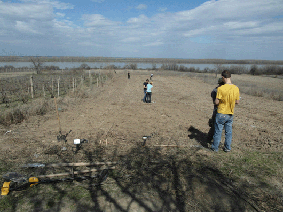
In August 2011, the team conducted a series of tests, which aim was to choose proper methods
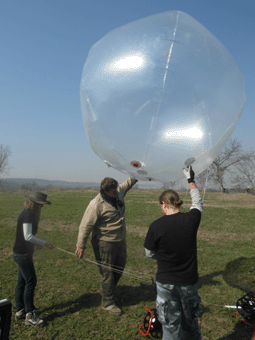
and devices. The remote sensing survey had been conducted by M. Jaworski and P. Wroniecki. The aerial
photographs thanks to the use of a helium balloon had been taken by J. and M. Pisz (IAUW). The survey with metal detectors as well as the elaboration of the metal finds was performed by P. Jaworski (IAUW). The team leader is dr A. Tomas (IAUW), who also conducted a query
financed by the Foundation for Polish Science. The field survey has started in March 2012 and will last
to the 2014 at least.
The project described above fits into
the socalled landscape archaeology as well as interdisciplinary researches conducted on the
Roman frontier zone. Similar surveys have been carried out in Netherlands, Germany and Austria.
We expect to collect a substantial amount of concrete information, enabling us to recreate the conditions of living if the legionaries and civilians from the neighbouring settlements.
The obtained results will help present and future archaeologists, who are looking for answers regarding the conditions of life and serviec, as well as the reception towards the place they were living in.
The task of such difficult surveys due to the complex topography of the area required a tight cooperation inside a team of numerous specjalists from diverse domains .
Considering supra-scientific issues emarging from such a project, we noted the formation of a modern team being able to work on so vasts settlements.
Agnieszka Tomas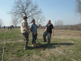
Survey in 2012 The survey covered the area of 2,07 ha placed on a high plateau located in the south-eastern part of Novae. The slope northwards was gentle, whereas the one southwards was step. The magnetic survey has also conducted both on the steep southern slope and the flat area situated at its foot. On the highest part of the surveyed area, i.e., the southern side of the fortress annex, witch covers a surface of around 8 ha, 25% of witch could be investigated. The surveyed surface reached almost 1.5 ha ot the estern annex and over 0.5 ha of the reae directly adhering to it from the south. Apart from the magnetic survey, flights were made with a helium balloon equipped with a photographic set in order to take a series of high resolution photographs used for prospection and documentation. Perpendicular pictures allowed us the preparation of orthophotomaps of the site. The data obtained during the past excavations, as well as historical, geophysical and photographical data will be collected GIS environment. Separate aerial prospection (orthophotomaps) and gIS for Novae will be performed during comming seasons. The detailed recording and mapping of metal finds will be conducted simultanously with geophysical prospection. The purpose of the joint methods is to find out their dating and evaluation of the stuctural remains observed on the images obtained during the remote sensing surveys. Preliminary results show a contituous habitation of this section of the Annex from the 1st to the 6th century AD. The vast amount of metal building elements (construction nails) and elements of military equipment point at the military character of this part of Novae in the late Antiquity. 
Survey in 2013
In 2013 the research in the eastern annexe was completed. Several places in the area of the western canabae were chosen for earth resistivity surveys.
One of the places, rich in finds visible on the surface, appeared to be severely eroded, but the finds, including pottery and glass, as well as human bones, may suggest
the presence of a cemetery there.
The main part of the survey was concentrated on the Ostrite Mogili site situated ca. 2.5 km to the east of Novae. The whole area was photographed by a remote controlled drone and
hexacopter. Field survey covered its eastern part. The finds visible on the ground suggest that the eastern end of the site was inhabited only in the early Medieval period (Slavic).
Numerous paleolithical tools have been found there, as well. The Roman site covers the area of ca. 12 ha. Magnetic survey has been conducted on the large part of the site.
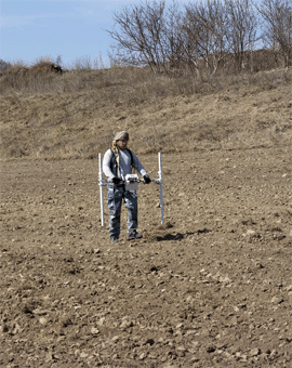
Some areas have been investigated with metal detectors. The field survey is supplemented by the query made in Bulgarian museums and archives SEE MORE Present ivestigations are being continued in the area of the annex of Novae SEE MORE Agnieszka Tomas, Marcin Jaworski, Piotr Jaworski, Joanna & Michał Pisz, Piotr WronieckiPublications:
A. Tomas (with P. Vladkova), Extramural area [in] Novae. An archaeological Guide (T. Sarnowski ed., A.B. Biernacki, P. Vladkova, M. Lemke), Warszawa 2012, 77-92. |


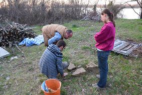
 The site has been destroyed by illegal digs. In one of the trenches we have found a wide wall made of re-used materials, including architectural elements and
fragments of inscriptions. This monument is of special importance: this is the first inscription on this site found in situ.
The site has been destroyed by illegal digs. In one of the trenches we have found a wide wall made of re-used materials, including architectural elements and
fragments of inscriptions. This monument is of special importance: this is the first inscription on this site found in situ.


© Departament of Archeology of The Roman Provinces